
11Weather
See the rain now, the official warnings and the weather at every stop. Check it before you pack up, so the weather doesn't catch you out.
11.1Rain radar
Rain radar shows where rain is falling right now. It's a picture made by weather stations that bounce radio waves off rain. It's on when you first open the app.
On a phone, Weather sits in the search bar at the top of the map. It's green, with an x, while the radar or the warnings show. On a computer, the Weather button on the right turns green. Both turn Rain Radar (live) and Severe Weather Warnings on the Weather tab on and off together.
- Tap Weather to hide the rain and the warnings. On a computer, tap Weather on the right.
- Tap it again to bring the rain back.
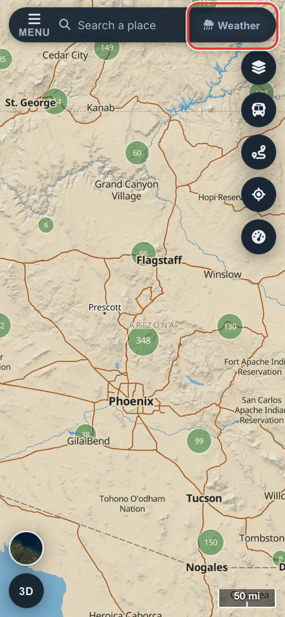
The radar is brightest when you're zoomed out. It fades as you zoom in, and it's gone at street level. Zoom out to see where the rain is.
| Colour | What it means |
|---|---|
| Pale blue | Drizzle |
| Blue | Light rain |
| Dark blue | Moderate rain |
| Orange | Heavy rain |
| Red to purple | Intense rain |
The app gets a new radar picture every 5 minutes.
Step by step, with pictures: See the weather on your trip
11.2The Weather tab
The Weather tab holds the weather switches for the map.
- Tap Menu at the top left.
- Tap Weather along the top of the menu.
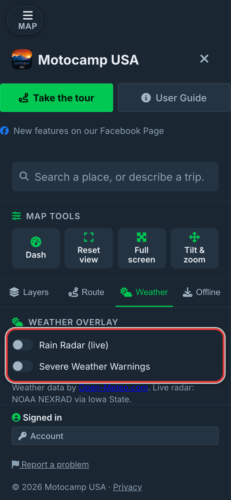
| Part | What it does |
|---|---|
| Rain Radar (live) | Shows rain falling now. On to start with. |
| Severe Weather Warnings | Shows official warnings as purple areas. On to start with. |
| Forecast Time | A slider that picks the hour for Location Weather. |
| Legend | Shows what the colours mean. |
| Location Weather | The weather at a spot you tap on the map. |
The two switches work on their own. The Weather button on the map turns both on or off together.
11.3The Forecast Time bar
The Forecast Time bar is a slider under the switches. It runs from Now to +7 days, in three hour steps.
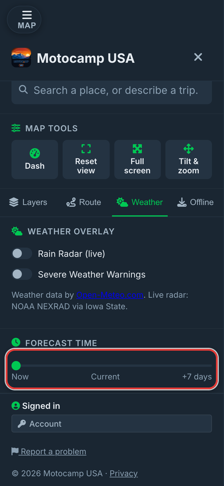
Slide it right to pick an hour. The label shows the day and the hour. The bar sets the hour for Location Weather.
11.4Weather at a spot you tap
You can check the weather at any spot on the map.
- Make sure Rain Radar (live) is on.
- Tap an empty part of the map, away from pins and your route.
- Tap Menu, then Weather, to read it under Location Weather.
| Figure | What it means |
|---|---|
| Picture and words | The sky, such as Partly cloudy or Light rain. |
| °F | The temperature. |
| mph | The wind, in miles per hour. |
| in | Rain, in inches. |
| Cloud % | How much of the sky is cloud. |
| % humidity | How damp the air is. |
Hold your finger down on the map to open What's here. It shows seven days of weather for that spot, with the high, the low and the rain for each day.
11.5Weather at each stop on your route
Plan a route, and the Route Summary shows a weather card for each place. There's one for the Start, one for each Stop and one for the Destination.
- Tap Menu, then Route.
- Add your start and end, then tap Plan Route.
- Scroll down the Route Summary to the cards for each place.
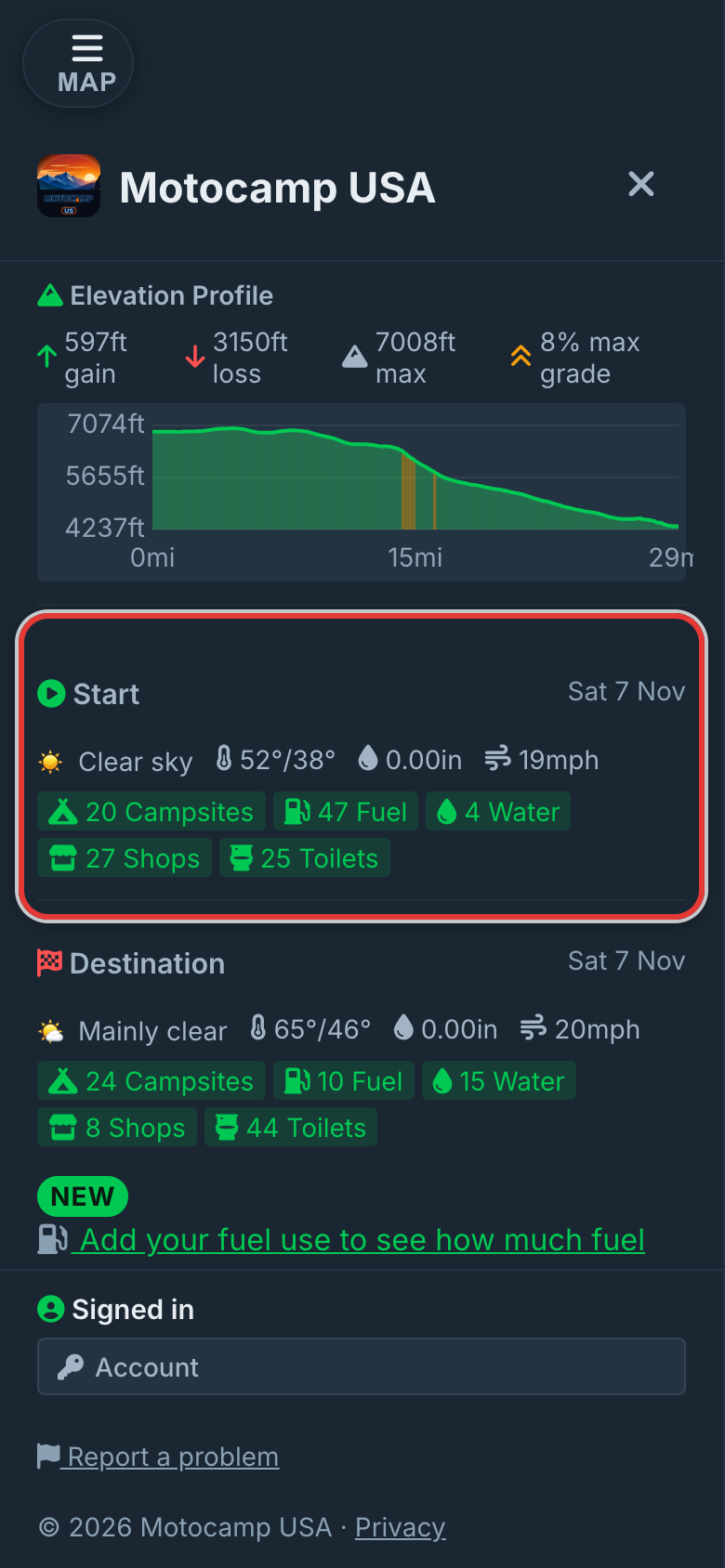
Each card shows one day. The Start shows today. The first stop shows tomorrow, the next stop the day after, and so on. After seven days, every later stop shows day seven.
| Figure | What it means |
|---|---|
| Date | The day this card is for. |
| Picture and words | The sky that day, such as Overcast or Heavy rain. |
| Two temperatures | The high and the low for the day, in °F. |
| in | How much rain is expected that day, in inches. |
| mph | The strongest steady wind that day, in miles per hour. |
Each card also lists campgrounds, fuel, water, shops and toilets near that place.
11.6Weather warnings on your route
The app checks each place's forecast for bad weather. Anything it finds goes in the Warnings list in the Route Summary.
| Warning | When it shows |
|---|---|
| Heavy rain, heavy snow, heavy showers or a thunderstorm at a place | When that's the forecast. It says how many inches to expect and to think about waiting or going another way. |
| Heavy precipitation at a place | Rain or snow of more than about 0.4 inches in the day. |
| Strong winds at a place | Wind over about 34 mph. Over about 45 mph it's marked as serious. |
| Freezing conditions at a place | A low below 32°F. It warns of ice on the road. |
| Extreme heat at a place | A high over 104°F. It tells you to carry extra water. |
Official weather warnings are on the map too. If one covers part of your route on your trip day, it's listed as well.
Step by step, with pictures: See the weather on your trip
11.7Official warnings on the map
Official warnings show as purple areas on the map. Each has its name on it. They come from the National Weather Service.
They're on to start with, because a warning you have to look for is no help. If you're planning a trip for another day, you can hide them: turn off Severe Weather Warnings on the Weather tab, or tap Weather on the map. A warning in force on the day of your trip is still listed in the Route Summary.
| Colour | What it means |
|---|---|
| Deep purple | The most serious level. |
| Purple | A serious warning. |
| Pale purple | A lower level. |
- Tap a purple area.
- Read the card. It shows the warning, the area, what to do, when it starts and ends, and who issued it.
With signal, the app looks for new ones every 10 minutes.
There's also a Weather Alerts switch, under Live Hazards on the Layers tab. It's off to start with. It adds a dot for each serious National Weather Service warning.
| Dot | What it means |
|---|---|
| Red | Extreme |
| Orange | Severe |
| Grey | Moderate |
Tap a dot to read the warning and see the area it covers.
11.8Weather with no signal
When you plan a route, the app saves a week of forecasts along it to your phone. It takes a point about every 25 miles, up to 25 points.
When it's done, the Route Summary shows Offline ready, with the words 7-day weather cached along this route. Those forecasts keep working when you lose signal.
A forecast more than two hours old says when it was saved. It refreshes by itself when you're back in signal.
Downloading a state on the Offline tab saves some forecasts for it too.
11.9Temperatures and units
The app uses US units, and there's no switch to change them.
| What | Shown in |
|---|---|
| Temperature | °F |
| Rain | in, inches |
| Wind | mph, miles per hour |
| Air pressure on the Dash | inHg, inches of mercury |
Dash opens a dashboard with your speed and height. On a phone, it's in the Menu, under Map tools. Its top bar shows the temperature, the air pressure and the wind where you are. An arrow beside the pressure shows if it's rising or falling. Falling pressure often means bad weather is coming. Its RAIN panel is a small radar of the area around you.
11.10Webcams
See a pass or the coast before you drive there. The Webcams switch puts cameras on the map, like Donner Summit on I-80 and Berry Summit on SR-299.
- Tap Menu at the top left.
- Tap Layers along the top of the menu.
- Under Live Hazards, turn on Webcams.
- Tap a camera on the map.
A purple camera looks at mountains or a pass, a teal one at the coast, and a small grey one at the road.
Caltrans cameras in California show their picture right on the map. Thousands more cameras across the country belong to their owners, so tapping one opens the owner's page.
11.11Where the weather comes from
| What | Where it comes from | How fresh |
|---|---|---|
| Rain radar | NOAA weather radar stations, through Iowa State University | New picture every 5 minutes |
| Forecasts at stops and at a spot | Open-Meteo, a free weather forecast service | Checked again after about 15 minutes |
| Official warnings | National Weather Service | Checked every 10 minutes |
| Dash weather | Open-Meteo | Every 5 minutes while the Dash is open |
| Webcams | Caltrans, and webcams listed in OpenStreetMap | Each camera's own picture, most every 5 to 15 minutes |
NOAA is the US weather agency.